


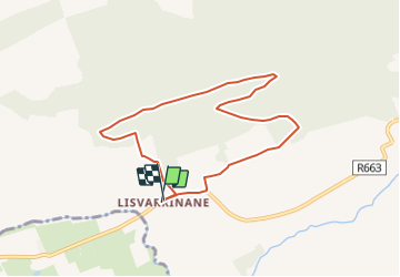
Padraigh Loop

mlmoroneybb
User

Length
6.8 km

Max alt
254 m

Uphill gradient
171 m
Km-Effort
9.1 km

Min alt
100 m

Downhill gradient
168 m
Boucle
Yes
Creation date :
2014-12-11 00:00:00.0
Updated on :
2014-12-11 00:00:00.0
--
Difficulty : Unknown

FREE GPS app for hiking
 SityTrail
IGN / Geographical institutes
SityTrail Plus
The world is yours!
About
Trail Walking of 6.8 km to be discovered at Unknown, County Tipperary, The Municipal District of Cahir — Cashel. This trail is proposed by mlmoroneybb.
Positioning
Country:
Ireland
Region :
Unknown
Department/Province :
County Tipperary
Municipality :
The Municipal District of Cahir — Cashel
Location:
Clonbeg
Start:(Dec)
Start:(UTM)
552536 ; 5807101 (29U) N.
Comments